Mar Elias Monastery

Greek Orthodox monastery in south Jerusalem.


The sixth-century Mar Elias Monastery named after Elijah.

Mar Elias Monastery is a Greek Orthodox monastery in south JerusalemMar Elias Monastery is a Greek Orthodox monastery in south Jerusalem


The Shrine of the Ba'b (Haifa)

 Bahá'í Gardens in Haifa - Shrine Gardens.

Designed by distinguished Canadian Architect William Sutherland Maxwell, the architecture of the Shrine of the Ba'b is a marvellous blend of western and eastern styles.


The granite columns proclaim the glory of classic Roman architecture; the Corinthian capitals are reminiscent of ancient Greece, while the majestic arches bring the flavour of the Orient.

The Gardens in Haifa - The Bahá'í GardensBahá'í Gardens in Haifa - Shrine Gardensthe Hanging Gardens of Haifathe Hanging Gardens of Haifa إسرائيل في صور - ضريح البابIsrael Travel Guide - The Shrine of the Ba'b (Haifa) Bahá'í World Centre, Bahai GardensIsrael Travel Guide - The Shrine of the Ba'b (Haifa) Bahá'í World Centre, Bahai GardensIsrael Travel Guide - The Shrine of the Ba'b (Haifa) Bahá'í World Centre, Bahai Gardens


Terraces of the Shrine of the Ba'b

Since 1987 work has been under way to enhance the surroundings of the Shrine of the Ba'b by constructing 18 monumental terraces from the foot to the crest of Mount Carmel, nine above and nine below the Shrine.

Architect Fariburz Sahba, whose design of the Baha'i House of Worship in India commonly known as the Lotus Temple has won international acclaim, has designed these terraces as hanging gardens on the slopes of the Carmel range to create an appropriate setting and approach for this Shrine, one of the most sacred spots for Baha'is.


The Architect explains: The Shrine of the Ba'b is envisaged as a precious gem, for which the terraces provide the setting, like a golden ring for a precious diamond. The terraces are designed as 9 concentric circles, appearing to emanate from the Shrine of the Báb. All their lines and curves direct the eyes and feelings towards that central edifice. The geometry of parallel surfaces and lines have been employed to create the most agreeable and comforting setting for the spectator along the entire landscape.

The natural elements of light and water form the main decoration of the terraces, though a number of beautiful ornaments also adorn the gardens.

The terraces stretch about a kilometre up the mountain reaching a height of 225 metres, and their landscape spans the mountain from 60 metres to almost 400 metres.

One of the distinguishing features of these gardens is the attention paid to conservation of the environment and water resources.

A highly sophisticated state-of-the-art irrigation system has been put in place to conserve water.


Kfar Saba


A city in the Sharon area, the center District of Israel with a population of 83.000 inhabitants.


Kfar Saba is named after the ancient Capharsaba, which was an important settlement in the Southern Sharon during the Second Temple Period. Capharsaba is mentioned for the first time in the writings of Josephus FIavious, in a description of King Alexander Jannaeus' (126-76 BC) attempt to stop an invasion from the north:
"He (Antiochus, who was called Dionysius) also came immediately and made expedition against Judea, with eight thousand armed footmen and eight hundred horsemen. So Alexander, out of fear of his coming, dug a deep trench, starting at Chabarzaba, which is now called Antipatris, to the sea of Joppa, on which part only his army could be brought against him" (Antiquities book 13, Ch. 15:1).

There is also reference to the name in the Talmud tractate on "corn tithing", where the "tale of the Capharsaba sycamore tree" is told.

It is known fact that Rabbi Meir and many Tana'ites lived in Capharsaba, which was located on the site of the sabiya ruins (today's Shabbazi and Aliya neighborhoods).


The History of Kfar Saba:
Ancient maps verify Kfar Saba's place of prominence and continued existence, all the way from its beginning days to our own.

Arab Kfar Saba, which was located in what are now the Kaplan, Yosefthal, and Givat Eshkol neighborhoods, was no more than a village which came unto being in the last century, and took up the name of the original settlement.
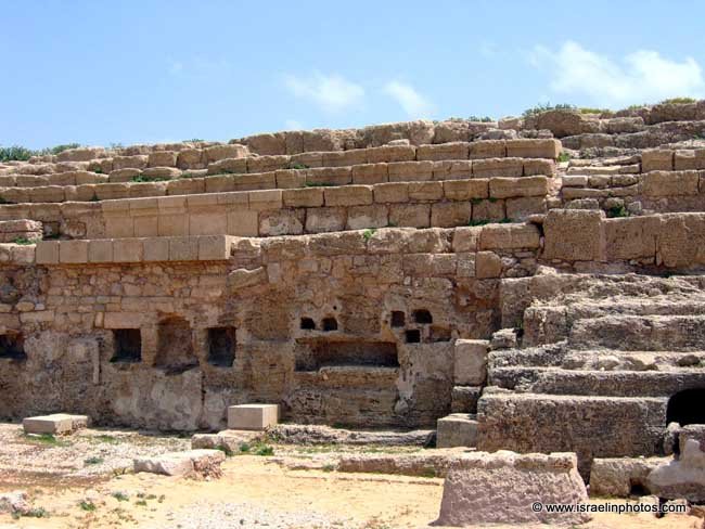
The village was abandoned during the War of Independence. Ruins of a large ancient settlement were uncovered underneath the Arab homes. Nowadays there is a public park on the site, which is in the city's eastern and, between Givat Eshkol and the Geller community center.

Large stone cylinders were found on the site, pitted with holes. These cylinders were part of an oil press. Excavations from the top of the mound have managed to reach the original soil layer, unearthing remains of a settlement from the Roman Era, in addition to many other findings. Clay oil lamps, called the "Samaritan oil lamps", which are believed to have been used by the Samaritans, stand out in particular. The "corn tithing" tractate in the Jerusalem Talmud (22:3) mentions the fact that Samaritans were living in Capharsaba. The settlement is also mentioned in other Jewish and foreign sources.

It is quite likely that Saba was the name of the original settler (being also the name of the well known Judean Desert monastery-Mar Saba). In all likelihood the name was later taken up by the entire family, which settled in the valley. The family, in turn, gave the name to the entire region, as well as to the village.


The Sabiya Ruins:
These are the remains of a settlement situated on the western section of the city, along the road which ran across the country, on the way to Apollonia. The site is known by its Arabic name - the Sabiya ruins, meaning a sub settlement, or a satellite of the greater Kfar Saba. The Sabiya ruins extend over an area of about 60 dunam (15 acres), on the eastern side of the Aliya neighborhood, between the health clinic and the football field. This site was also researched and surveyed, yielding coins, oil lamps, a handle of a storage jar bearing an inscription in Arabic: "Blessing upon the governor", and a large four-handled jug. A well constructed mausoleum, dating to the Roman Era, which was in use for 300 years, was discovered in close proximity to the clinic. A large underground structure, dating to the Byzantine period, was unearthed in the heart of the site. It is inlaid with white mosaic and with clay pots, which were laid horizontally, inside the walls.

It is interesting to note that no "Samaritan" oil lamps were discovered on this site, which indicates that the Samaritans probably did not inhabit the place during the Roman Era. Large cylinders, parts of an oil press, were found here too.

Many blocks of crude glass, remains of kilns and ashes, testify to the existence of a large scale glass industry in the ancient settlement.

Jews acquired land in Kfar Saba as early as 1892. Rabbi Yehi'el Michal piness purchased land for an agricultural settlement, but the land remained desolate for 7 more years. In the course of these years, while the land was in possession of Baron Rothchild, an attempt was made to grow jasmine flowers for perfume, but the experiment failed. It was only in the year 1903, when the land was turned over to Petah Tikva farmers for tilling and cultivating, that the new settlement - which was to be named Kfar Saba - was actually established. To begin with - the khan (inn) - which now serves as city hall, was built. The settlers-cum-farmers convened around the Khan, and started out by planting eucalyptus and almond trees. Two of the original eucalypti can still be seen in the compound of the Municipality.

These two trees, and the first building, form the Kfar Saba emblem.

The first years proved difficult for the pioneers, because of the prohibitions and restraining measures imposed by the Turkish authorities. However, due to their determination, the pioneers were able to construct, in a matter of just a few years, 12 housing units, and thus the settlement started taking shape.

In World War 1, Kfar-Saba was on the front line between the British army and the Ottoman army, and was destroyed. At the same time about a thousand residents of Tel-Aviv and Jaffa came to live in the town. They had been forcibly deported from their homes by the Ottomans. Due to the pogroms of 1921 these deportees returned to their original cities. In 1922 the original residents returned and in 1924 additional settlers joined them. In this period the cultivation of citrus fruit developed.

In 1937 Kfar-Saba was declared a local council.

In the time of the Arab Revolt, in 1936-1939, as in the 1948 Arab-Israeli War, Kfar-Saba's population suffered from attacks by Arabs from the Arab, Saba village and other villages in the area. A short time before the Israeli declaration of independence these villages were conquered in operation Medina. In 1962 Kfar-Saba was awarded city status. At the time of the Six day war Kfar-Saba suffered attacks from the neighboring town of Qalqilya that is located just over the the 1949 armistice line with Jordan.

The Cactus Garden, Holon

'HaKaktusim Garden'.

Named after Yehudit and Naum Arazi The garden is located in Neot Yehudit neighborhood (corner of Jerusalem Ave. and Moshe Sharet St.)

HaKaktusim Garden - The Cacti Garden in HolonThe cactus garden in the town of HolonCACTUS GARDEN HOLON ISRAELCactus Garden in Holon – Cacti and desert plants in HolonCactus Garden in Holon – Cacti and desert plants in HolonCactus Garden in Holon – Cacti and desert plants in Holon

St. George's Cathedral, Jerusalem

Anglican cathedral in Jerusalem.

Planned by architect George Jeffery (1855–1935) in the neo-Gothic style at the end of the 19th century.
The first buildings were used as: workshops, orphanages, a school for girls and a a school for boys.

St. George's Anglican Cathedral and College
Churches of Jerusalem - St. George's Anglican Cathedral and College (Jerusalem in Photos)Churches of Jerusalem - St. George's Anglican Cathedral and College (Jerusalem in Photos)כנסיות בירושלים: קתדרלת סנט ג'ורג' - ישראל בתמונותכנסיות בירושלים: קתדרלת סנט ג'ורג' - ישראל בתמונות圣乔治座堂是一座圣公会主教座堂,位于耶路撒冷圣乔治座堂是一座圣公会主教座堂,位于耶路撒冷圣乔治座堂, 耶路撒冷, 以色列,旅游,图片,教堂,巴勒斯坦圣乔治座堂, 耶路撒冷, 以色列,旅游,图片,教堂,巴勒斯坦圣乔治座堂, 耶路撒冷, 以色列,旅游,图片,教堂,巴勒斯坦圣乔治座堂, 耶路撒冷, 以色列,旅游,图片,教堂,巴勒斯坦

Caesarea Maritima


The city was founded by Herod the Great (37-4BC) on the site of an ancient fortified town known as Strato's tower. Emperor Augustus gave it to Herod and he in return dedicated the name of the city to Caesar. After the Romans assumed direct control of Palestine in 6CE Caesarea became the capital.


The official representative of Rome had his residence there from this time, but the first of whom we are certain is Pontius Pilate (26-36CE); an inscription bearing his name was found in the ruins of the theatre. Cornelius, a centurion of the Roman garrison, was the first Gentile to be converted to Christianity by Peter (Acts 10). Paul was imprisoned for two years (58-60CE) in Herod's praetorium until he forced a decision by demanding to be judged by the emperor (Acts 23:6). Caesarea became one of the leading maritime cities.

In 66CE riots broke out between Caesarea's Jewish and Syrian communities, the desecration of the synagogue was one of the contributory causes of the First Revolt (66-70CE).

Vespasian established his headquarters in the city, and directed his operations from there. It received the status of a Roman colony, though with limited rights. In the third century the scholar Origenes established the famous school of Caesarea (231-250), that Pamphilus continued (309).His pupil Eusebius (260-340), who became Bishop of Caesarea in 314, is both the first church historian and the first biblical geographer. He wrote the Omnimasticon, a geographical bible dictionary within certain stated limitations.

With the Arab conquest in 640 the town declined in importance and Herod's splendid harbour decayed. In 1101 it fell to the Crusaders and in July 1187 to Saladin. He demolished the fortifications in 1191, as did al-Muazzam in 1219. The refortification that begun in 1228 was completed by Louis IX of France between March 1251 and May 1252. Caesarea was finally taken by Sultan Baibars in 1291 and destroyed by the Mameluks.

In 1878 the Turks installed Muslim refugees from Bosnia on the site and they founded a fishing village.

The area was developed with the help of the Rothschilds and has become a resort area.

Israel, Archeology and History, Caesarea Maritima, Travel, PicturesIsrael, Archeology and History, Caesarea Maritima, Travel, PicturesIsrael, Archeology and History, Caesarea Maritima, Travel, PicturesIsrael, Archeology and History, Caesarea Maritima, Travel, PicturesIsrael, Archeology and History, Caesarea Maritima, Travel, PicturesIsrael, Archeology and History, Caesarea Maritima, Travel, Pictures